Tuesday, December 4, 2007

Open Registration for Spring classes at AB Tech

Several GIS classes are being offered at AB Tech this spring and open registration is now! Classed begin Monday, January 14th, 2008.

GIS 111 - Introduction to GIS is being offered in 4 sections.

  • GIS111 YD1 - Meets M/W from 10 - 11:20. This class is a hybrid format meaning students will have 1 hour of online work per week in addition to outside time spent on homework assignments.
  • GIS111 LD1 - Meets M/W from 2:10-4:00pm. Late start class. Class begins January 23rd.
  • GIS 111 O1 - Online section. If you know you like online learning this one is for you. If you don't know if you like it or not ... a couple words of advice - it is MORE WORK than taking a traditional seated class, but it is more flexible.
  • GIS 111 WN1 - Meets Thursday nights 6:00pm -9:50pm. Web supplement accompanies course.
GIS 121 - Georeferencing and Mapping - one section
  • GIS 121 D1 - (prerequisite - GIS 111 or equivalent) - Meets M/W from 8:00am-9:50am.
GIS 215 - GIS Data Models - one section
  • GIS 215 N1 - (prerequisite - GIS 111 or equivalent) - Meets Tuesday nights from 6:00pm - 9:50pm
If you have any questions or would like to sign up for one or more of these classes, contact Pete Kennedy at 828.254.1921 x289 or email pkennedy(at)abtech.edu.

You can learn more about the GIS Certificate and ABTech by following

Thursday, November 29, 2007

Buncombe County Preliminary FEMA Map Review

I thought I would post this for anyone who is interested in the process of the floodplain mapping.

From the Asheville-Citizen Times (http://www.citizen-times.com/apps/pbcs.dll/article?AID=200771128023)

New Buncombe County flood insurance rate maps available for public review

by staff reports

published November 28, 2007 9:59 am

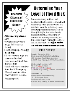
Raleigh – Three meetings are scheduled in Buncombe County for residents and the business community to review and ask questions about preliminary copies of newly updated Flood Insurance Rate Maps developed for the French Broad River Basin.

Advertisement

The meetings are:

Black Mountain - Tuesday, December 11th. Maps will be on display beginning at 6:00 p.m.; a presentation on the material will begin at 6:30 p.m. in the Black Mountain Public Safety Building, 106 Montreat Road, in Black Mountain.

• Enka - Wednesday, December 12th. Maps will be on display beginning at 12:30 p.m.; a presentation on the material will begin at 1:00 p.m. at the A-B Tech Enka Campus, in the Haynes Building, Room 200, 1459 Sand Hill Road in Enka.

Asheville - Thursday, December 13th. The maps will be on display beginning at 6:00 p.m.; a presentation on the material will begin at 6:30 p.m. in the Asheville Public Works Building, large conference room (Room A109), 161 S. Charlotte Street, in Asheville.

Digital versions of the three Buncombe County preliminary maps are currently available for public review by contacting your local planning department or searching the North Carolina Floodplain Mapping website at www.ncfloodmaps.com.

County and municipal officials will be on hand at each of the three sites to help residents locate particular properties on the maps and determine their level of flood risk. Representatives from the North Carolina Floodplain Mapping Program and North Carolina Floodplain Management will make short presentations on the map production process, features of the new maps, how they can be used to reduce future losses due to flooding, and their connection with flood insurance and floodplain management. Attendees may also see a demonstration of the North Carolina Floodplain Mapping Information System. Following the presentation, state and Federal Emergency Management Agency (FEMA) representatives will be available to answer questions about the mapping process, flood insurance coverage, and floodplain management topics.

The three meetings provide an opportunity for residents to see the results of the advanced digital technology used to create the new flood maps. Black Mountain residents should go to the presentation in Black Mountain, Asheville residents to the Asheville meeting and county residents to the Enka meeting

Wednesday, November 28, 2007

WNC GIS Gathering this week!

When: Thursday, Dec. 29th - 5:00pm - until
Where: Asheville Pizza Company - Downtown on Coxe Ave.

Come visit and see what's going on with the world of GIS

Madison County GIS Day POSTPONED

The Madison County GIS Day WILL NOT BE HELD THIS SATURDAY (DEC. 1). It will be rescheduled for sometime in January. Check back for details.

Wednesday, November 7, 2007

Other GIS Day events

If you haven't seen all the great GIS Day events going on in the mountains, Greg Dobson did a great job of summarizing them all on http://mrgac.blogspot.com. Check it out - see you Friday!

Tuesday, November 6, 2007

GIS Day schedule of events

For Friday, November 9th - hosted by AB Tech with tons of great participants.

Check the schedule of events here!

Tuesday, September 25, 2007

GIS DAY 2007 - Celebration of all things GIS in and around Asheville

Start planning now to come see what's going with GIS in and around Asheville on Friday, November 9th. The event is being held at the AB Tech Asheville campus and promises to be exciting. Thanks to all the sponsors and demonstrators who are making this happen. They include:
  • Asheville-Buncombe Technical Community College – GIS Certificate Program
  • Buncombe County - GIS Department
  • City of Asheville – GIS Department
  • ESRI - Scott Wolter (Charlotte Office)
  • FGDC / GeoMaxim – Linda Wayne
  • NC Center for Geographic Information and Analysis
  • Renaissance Computing Institute (RENCI)
  • Resource Data Inc. - Neil Thomas
  • UNC Asheville - National Environmental Modeling and Analysis Center (NEMAC)

We'll have presentations of all the latest internet-based GIS applications from the City and County, the NC CGIA will be on hand talking about state level GIS coordination, Linda Wayne from GeoMaxim and FGDC will be talking standards and the National Spatial Data Infrastructure and cross-organizational geospatial collaboration, ESRI will be represented by Scott Wolter, Neil Thomas will be here showing some of his exciting work at Resource Data Inc., NEMAC will be here with the GeoDome and RENCI emergency response van and much much more.

WHEN? Friday, November 9th, 2007. 9:00am - 2:00pm

WHERE? AB TECH Asheville Campus - Balsam Building

WHAT? Open House event with lots of demonstrations. Come drop in or stay all day!

More information - see http://gis.esri.com/gisday/detail.cfm?id=9093