
 From the Asheville-Citizen Times (http://www.citizen-times.com/apps/pbcs.dll/article?AID=200771128023)
by staff reports
published November 28, 2007 9:59 am
Advertisement
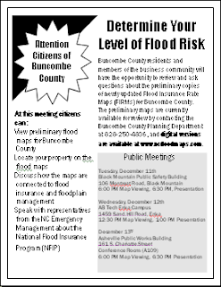
The meetings are:
•
• Enka - Wednesday, December 12th. Maps will be on display beginning at 12:30 p.m.; a presentation on the material will begin at 1:00 p.m. at the A-B Tech Enka Campus, in the
•
Digital versions of the three
County and municipal officials will be on hand at each of the three sites to help residents locate particular properties on the maps and determine their level of flood risk. Representatives from the North Carolina Floodplain Mapping Program and North Carolina Floodplain Management will make short presentations on the map production process, features of the new maps, how they can be used to reduce future losses due to flooding, and their connection with flood insurance and floodplain management. Attendees may also see a demonstration of the North Carolina Floodplain Mapping Information System. Following the presentation, state and Federal Emergency Management Agency (FEMA) representatives will be available to answer questions about the mapping process, flood insurance coverage, and floodplain management topics.
The three meetings provide an opportunity for residents to see the results of the advanced digital technology used to create the new flood maps.