Here at the City of Asheville we've focused a lot of energy on enhancing our online GIS offerings.
Several months back I ran across across some information for the GeoWeb conference that occurred last week. I decided to skip my usual trip to the ESRI conference this year and instead learn a little bit more about the GeoWeb. This concept of a GeoWeb means a lot of different things to a lot of different folks. I think the focus of the conference is best summed up as the convergence of geospatial information, emerging web technologies, and standards. The conference was amazing. Keep an eye on their web page for the proceedings to be posted.
I'd like to share some of this experience with our local/regional GIS community...
Being in a small venue with only 150-200 people and hearing folks like Jack Dangermond (owner ESRI), Vincent Cerf (co-designer of the TCP/IP protocols and the architecture of the Internet), Michael Jones (CTO Google Earth), and Vincent Tao (director Microsoft Virtual Earth) was pretty cool. To hear Vincent Cerf and Jack Dangermond politely debate points and to be able to watch Michael Jones' facial expressions at the same is a great opportunity for insight on the industry!
The breathtaking pace of standards based innovation is what made the most lasting impression on me. Anybody here know what GML, WMS, WFS, WFS-T, WCS are? Your organization may have a WMS service that feeds NCOneMap but I challenge you to see if it is up and running... More than half of the services listed in NCOneMap catalog appear to be inaccessible. I'll use my own organization to make my point. Until this morning the WMS service that we thought was feeding NCOneMap was down and has probably been down for over a year. Unfortunately, standards have not been on the forefront of our ESRI-biased minds. I'm determined to change that. Important efforts like NCOneMap and the National Spatial Data Infrastructure rely on standards. Check out the Open Geospatial Consortium for loads of good info on standards that should be important to us.
Speaking of the National Spatial Data Infrastructure, SDI is about become an acronym that we should all be familiar with. GIS finally meets IT in the mainstream.
Bunches of great opensource geospatial tools out there these days... my staff grimaces at the prospect but I have a vision of creating a separate opensource/standards-based application stack to handle our web mapping needs. Take a look at OSGeo for the latest happenings in that realm.
I'll get off my soapbox in a moment but I'd like to draw your attention to a sweet little free download from the Carbon Project : Gaia 3. This application will allow you to pull in map services (standards based) from just about anywhere you please and overlay them on the fly (one big downside: no re-projection). You can pull in Google Earth KML files, Microsoft Virtual Earth imagery, Yahoo! transparent roads, local goverment data, federal data, etc. It's a real quick and easy way to mash-up content from just about anywhere. Just think what might be possible if all of us in our local/regional GIS community implemented OGC standards and could quickly mash-up up our data on the fly... large-scale disaster response is what first comes to my mind but the possibilities are truly limitless. Download Gaia and an example file that I've posted here and check it out.
If ya can't tell, I'm pretty excited about some things that I've learned recently!
Friday, August 3, 2007

Thursday, August 2, 2007
The WNCGIS Gathering July 26, 2007

 The WNCGIS July Gathering took place at the Asheville Brewing Company on Coxe Ave in downtown Asheville. We had a robust turnout and more interesting conversations than I could keep track of. We had a few new people join in the fun, including the esteemed Eric Ringler (from Polaris Maps) and Sherry Ingram (who recently started an Environmental Consulting Company). We also got the news that Danitza Earl has a new job with a Land Trust. She might make a blog post soon about the details. In other news, the URISA and GITA conference is coming up in Charlotte on September 5th. It sounds like it will be a packed conference; Neil Thomas and I should be presenting some of our work there.
Monday, July 23, 2007
New GIS Certificate underway at AB Tech
Interested in how you can use GIS to better do your job or just wondering what all the buzz is about? Asheville-Buncombe Technical Community College is now offering a 4-course certificate in GIS. The current course offerings can be seen below.
GIS 111 - Introduction to GIS
GIS 121 - Georeferencing and Mapping
GIS 215 - GIS Data Models
and one of the following other courses:
CIS 110 - Computer concepts
CIS 115 - Introduction to Programming and logic or
DBA 110 - Database Concepts
GIS 111 - Introduction to GIS
GIS 121 - Georeferencing and Mapping
GIS 215 - GIS Data Models
and one of the following other courses:
CIS 110 - Computer concepts
CIS 115 - Introduction to Programming and logic or
DBA 110 - Database Concepts
AB Tech is taking a unique approach to teaching Geospatial Technology by offering classes in the Computer Information Technology Department. This approach will allow GIS, GPS and other related technologies to be taught in the broader context of information systems while capitalizing on existing programs and certificates already at the college in Web Technologies, Database Technologies, and Interactive Multimedia. This certificate provides a strong foundation in Geospatial Technologies with more classes planned in the Database, Web and Multimedia programs.
Come take GIS from ESRI Authorized Instructors and Trimble Certified Trainers at AB Tech!
See the fall schedule of GIS classes below -

For more information.... see our blog below
or you could always call, email or stop by with any questions!
pkennedy (at) abtech.edu
828.254.1921 x289
Monday, July 2, 2007
Hawth's Tools
 So this is probably not new and exciting to everyone else, but I recently ran across the Hawth's Analysis Tool Set available at http://www.spatialecology.com/. This is an extremely useful set of tools for anyone doing any type of ecology work with ArcMap as it expands Arc's functionality in this area.
So far the features that I have found most useful and the biggest time savers are the ability to generate random points and the ability to create evenly spaced grid shapefiles. It also has other features which I have yet to exploit including animal movement simulation.
Perhaps the most attractive part of this tool is that it is completely free and it easily installs and integrates with the Arc products. Please don't let me limited review deter you, this is definitely something worth checking out.
Thursday, June 28, 2007
JAVA / GIS Contract job
Hi all,
I had someone inquire about a good JAVA programmer with some GIS experience for a 3 month contract job. I thought I would post it here to see if there is any interest. Please pass along to anyone you can think of that may be able to do this kind of work. This is the kind of work that would be great to keep in our local pool of talent without having to outsource.
Java Programmer With GIS Experience
Lab Escape is looking for an experienced Java programmer with GIS experience to add geographic mapping capabilities into our visual analysis software. Experience with GeoTools is a plus. This is a contract position for 3 months. Development firms with relevant experience may apply. If interested, please contact Trevor Lohrbeer at resumes@labescape.com.
Sunday, June 3, 2007
The May 30th WNCGIS Gathering

The May Gathering at Dirty Jacks in downtown Asheville was another fun time for everyone in our GIS community. We got a chance to look at the maps for the Map Contest, and everyone put in a vote for their favorite. Although all the maps were very nice, I'm pleased to announce that the ever-industrious Josh O'Conner had the most votes. He won a coveted Malaprops Gift Certificate. To the left you can see him proudly displaying his prize.
A Big "Thank You" goes out to everyone who participated in the Map Contest. We hope that we will continue to get support and entries for the contest, so that we can select a winner or two bi-monthly. As you may recall, having a theme of some kind for each contest cycle was one idea, so if anyone would like to see a particular theme for the next contest, let us know.
Friday, June 1, 2007
CommunityViz
I thought I would post some information on the CommunityViz software package and some of its more useful features. The package functions as an extension for the ArcGIS products. It allows for the creation of dynamic data that allows for scenarios to be created in a sort of "What if?" analysis.
I have just been toying with it a little over a week and I intend to use to construct some data correlating Hemlock die back with stream temperature increases. The program seems to be primarily designed to use in community planning operations but can be extended for more ecological centered uses.
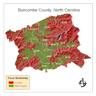
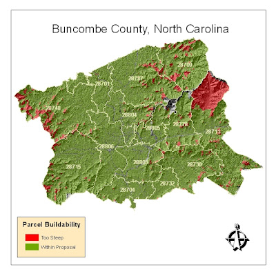
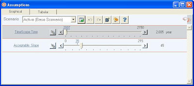
In order to learn the basics of the program I began toying around with average parcel slope data in Buncombe county. I then set a dynamic threshold on allowable slope percentage within the parcels (so that it would be easy to understand the volume of parcels that would be affected by various limitations on development in sloped areas). The first map is set with a maximum allowable slope of somewhere around 20% (yes, low, I know). Using the slider bar with the variable constructed in CommunityViz, the map can be updated dynamically to show what would happen should an ordinance be proposed that barred development on in parcels with slopes that are greater than 45%.
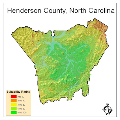
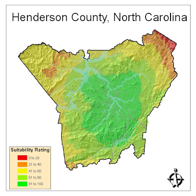
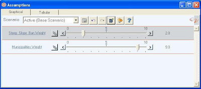
In order to understand how CommunityViz could perform with weighing two variables within a single map I constructed a similar analysis that factored in parcel slope and distance to a city. Say in case a developer was looking for a location to build a retirement community and wanted to select land that wouldn't be too steep, thus deterring older occupants; at the same time this developer would want to build within reasonable proximity to the cities of Flat Rock or Hendersonville because of their notoriety among retirees. The first map shows both factors with equal weight. The second shows what would occur if the developer became less concerned with parcel slope but really wanted to cash in on people heading toward Flat Rock or Hendersonville.
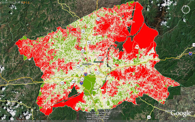
One last feature worth noting is the seamless integration with the Google Earth platform. Following the analysis of the Buncombe County slopes, I exported the data to Google Earth so that it could be made accessible to a wider user base (this is with the data with maximum slope set at 20%).
Clicking on the thumbnails will yield better pictures and I will post more as I play with the program more.
I have just been toying with it a little over a week and I intend to use to construct some data correlating Hemlock die back with stream temperature increases. The program seems to be primarily designed to use in community planning operations but can be extended for more ecological centered uses.
In order to learn the basics of the program I began toying around with average parcel slope data in Buncombe county. I then set a dynamic threshold on allowable slope percentage within the parcels (so that it would be easy to understand the volume of parcels that would be affected by various limitations on development in sloped areas). The first map is set with a maximum allowable slope of somewhere around 20% (yes, low, I know). Using the slider bar with the variable constructed in CommunityViz, the map can be updated dynamically to show what would happen should an ordinance be proposed that barred development on in parcels with slopes that are greater than 45%.


In order to understand how CommunityViz could perform with weighing two variables within a single map I constructed a similar analysis that factored in parcel slope and distance to a city. Say in case a developer was looking for a location to build a retirement community and wanted to select land that wouldn't be too steep, thus deterring older occupants; at the same time this developer would want to build within reasonable proximity to the cities of Flat Rock or Hendersonville because of their notoriety among retirees. The first map shows both factors with equal weight. The second shows what would occur if the developer became less concerned with parcel slope but really wanted to cash in on people heading toward Flat Rock or Hendersonville.


One last feature worth noting is the seamless integration with the Google Earth platform. Following the analysis of the Buncombe County slopes, I exported the data to Google Earth so that it could be made accessible to a wider user base (this is with the data with maximum slope set at 20%).

Clicking on the thumbnails will yield better pictures and I will post more as I play with the program more.
Subscribe to:
Posts (Atom)